The KMA Oilfield did not come together quickly. Joseph A. Kemp, S.I. Munger, H.M. Munger, and Reece S. Allen purchased their first land in the area in 1912 — a thousand acres on a geological hunch, in country where no commercial oil had yet been confirmed. They waited nineteen years for their bet to pay off. When it did, they had one of the notable north Texas oilfields of the mid-twentieth century on their hands.
The field takes its name from the three founders: Kemp, Munger, Allen. It straddles the Montague-Wichita-Archer county boundary in north-central Texas, with the principal boomtown and field infrastructure on the Wichita County side and meaningful production on MoCo’s western flank. Over its operational lifetime, the KMA field covered approximately 135,000 acres and produced from more than 3,000 wells. Peak production came in the 1940s; the field continues producing at reduced rates into the twenty-first century.
What Led to the 1919 Discovery?
By 1919, the founders had organized the Kemp-Munger-Allen Oil Company (January 1919) and begun active drilling. Their first well flowed oil in October 1919, producing from shallow formations. Reports from August 1921 recorded production exceeding 7,000 barrels per day from this initial shallow zone — a meaningful figure for a north Texas field at the time.
Joseph A. Kemp was the operation’s public face: a Wichita Falls businessman with investments in banking, real estate, and water supply, his name attaches to Lake Kemp in Baylor County as well as the oilfield. The Munger partners and Reece Allen remain less documented — their biographical details are largely absent from available sources.
The shallow production ran through the 1920s, but saltwater intrusion created problems. Production from the shallow zones eventually declined, leaving the question of whether anything commercially viable lay deeper.
The March 1931 Deep Discovery
The answer came on March 11, 1931, when the Deep Oil Development Company completed a well at approximately 3,800 feet in the Strawn formation — a Pennsylvanian-age limestone that had not been the target of the earlier shallow drilling. The timing was punishing: the Great Depression had crashed oil prices, the East Texas Field’s 1930 discovery had flooded the market, and investment capital was scarce.
Despite those conditions, the Strawn discovery revitalized the field. Subsequent discoveries added producing zones:
- Kadane-Mangold zone (1937): flowing 2,000 barrels per day
- Ellenberger zone (1942): reached at approximately 4,300 feet
The geological picture that emerged was of a multi-zone field producing from Permian-age limestones and deeper Pennsylvanian and Ordovician formations, with moderate per-well rates but strong cumulative production.
The Kamay Boomtown
The principal boomtown that emerged from KMA development was Kamay (originally Kemp City), situated in Wichita County immediately west of the Montague County line. At peak:
- Population: 700
- 21 businesses serving field workers and their families
- Workers’ housing, supply stores, cafes, and service infrastructure
Kamay’s position on the Wichita County side reflects where the field’s infrastructure was concentrated — gathering pipelines, tank farms, processing facilities, and service roads were built for the producing zones closest to the boomtown. Montague County’s participation was real — royalty income to MoCo landowners, county tax revenue from production, employment in north MoCo communities — but secondary to the Wichita County center.
Kamay declined as field production declined. Its current population is a small fraction of its peak.
Production Peak and Long Decline
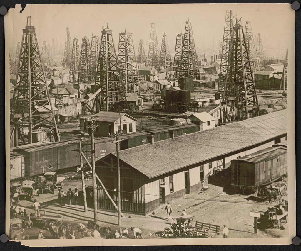
The KMA field reached peak production in the 1940s, when wartime demand drove output to maximum sustainable rates. The 1,500 or more active wells at peak represented one of the more significant north Texas producing concentrations of the mid-century period.
After the 1940s peak, the pattern was unambiguous decline:
- Older wells producing diminishing rates
- Workover activity (re-entering, deepening, hydraulic fracturing of individual wells) extending productive life
- Some infill drilling maintaining production at reduced levels
- Pumpjacks across the landscape pulling oil at slow rates from what had once been flush wells
The economics shifted steadily: from boom-time prosperity to routine royalty income to marginal stripper-well production. The field continues producing. The Texas Railroad Commission tracks it. Landowners in the MoCo portion of the field still receive royalty checks. But the KMA oilfield’s era as an economic driver closed with the 1940s.
What Happened Elsewhere in MoCo’s Oil Country
KMA dominates the story, but it was not the only petroleum activity in Montague County:
The Nocona area field produced oil as early as 1919, reportedly reaching peak production of more than 4 million barrels in 1927 — preceding the KMA deep discovery and suggesting that the broader regional petroleum potential was understood even as the KMA partners were still waiting for their deep test.
The Worsham Ranch discovery (early 1930s, Clay County–Montague County boundary zone) produced oil but in quantities insufficient to drive major development. It represents the pattern typical of secondary MoCo oil activity: something found, not enough to change the county’s economic character.
Wildcat wells scattered across MoCo through the 1910s–1960s produced mostly dry holes, with occasional marginal finds. The RRC’s well database records the full inventory; the county-specific count by outcome remains a research project. The wildcatter story is told separately in Wildcatters and Lost Wells of Montague County.
The Workers Behind the Wells
The KMA field at its 1940s peak — 1,500 active wells, Kamay at 700 residents — required hundreds of drilling hands, roustabouts, tool pushers, and pumpers. The field’s documentary record captures Kemp, Munger, and Allen in full biographical detail; the roughnecks who physically drilled the wells are absent from administrative records.
Their ethnic composition, wages, and boomtown living conditions are not captured in Texas Railroad Commission production data or TSHA secondary sources. Oil-field segregation patterns varied across Texas; whether KMA’s drilling crews were racially integrated or separated by race at the job level is not confirmed in available sources. The tenant farmers displaced by the boll weevil collapse after 1910 formed a labor pool that oil companies throughout north Texas recruited directly; whether that pattern held at KMA requires oral history research.
The University of North Texas Oral History Program and the Dolph Briscoe Center for American History (UT Austin Energy Industry Collections) are the designated research silos for KMA roughneck labor documentation. Adults born 1940–1950 whose parents worked the 1920s–1930s field operations are in their late seventies and eighties in 2026 — this research window is closing.
KMA in the North Texas Oil Context
By Texas standards, the KMA field is mid-size. The East Texas Field (Joiner discovery, 1930) is incomparably larger; the Permian Basin’s aggregate production dwarfs the entire north Texas region. KMA’s peer group is the cluster of early-twentieth-century north Texas fields — Burkburnett (1912), Electra (1911), Ranger (1917) — that established the regional oil culture and brought the boom-town pattern to communities across the Rolling Plains and Red River country.
For Montague County specifically, KMA provided a layer of economic identity layered atop the dominant cattle-and-farming identity: mineral-rights consciousness, lease bonuses, royalty income, and the pumpjack landscape that still marks the county’s northwestern sector. Some MoCo families’ wealth was rooted in oil royalties as much as in cattle or crops. That dual identity — rancher and mineral-rights holder — is a characteristic north Texas formation, and the KMA oilfield is its Montague County foundation.
Related pages: Wildcatters and Lost Wells of Montague County · Cattle-Cotton-Oil Era Index
Sources: TSHA Handbook of Texas (KMA Oilfield, Joseph A. Kemp, Kamay entries); Wichita County Historical Commission, “KMA Oilfield” (2018); Beisch, Ginger Birdwell, KMA — Keeping Memories Alive: History of the KMA Oilfield, Wichita County, Texas; Texas Railroad Commission historical production data. The two-phase discovery narrative (1919 shallow / 1931 Strawn deep) is well-documented in these sources. MoCo-specific production allocation within the tri-county field is an outstanding research question pending Texas RRC well-level data query.