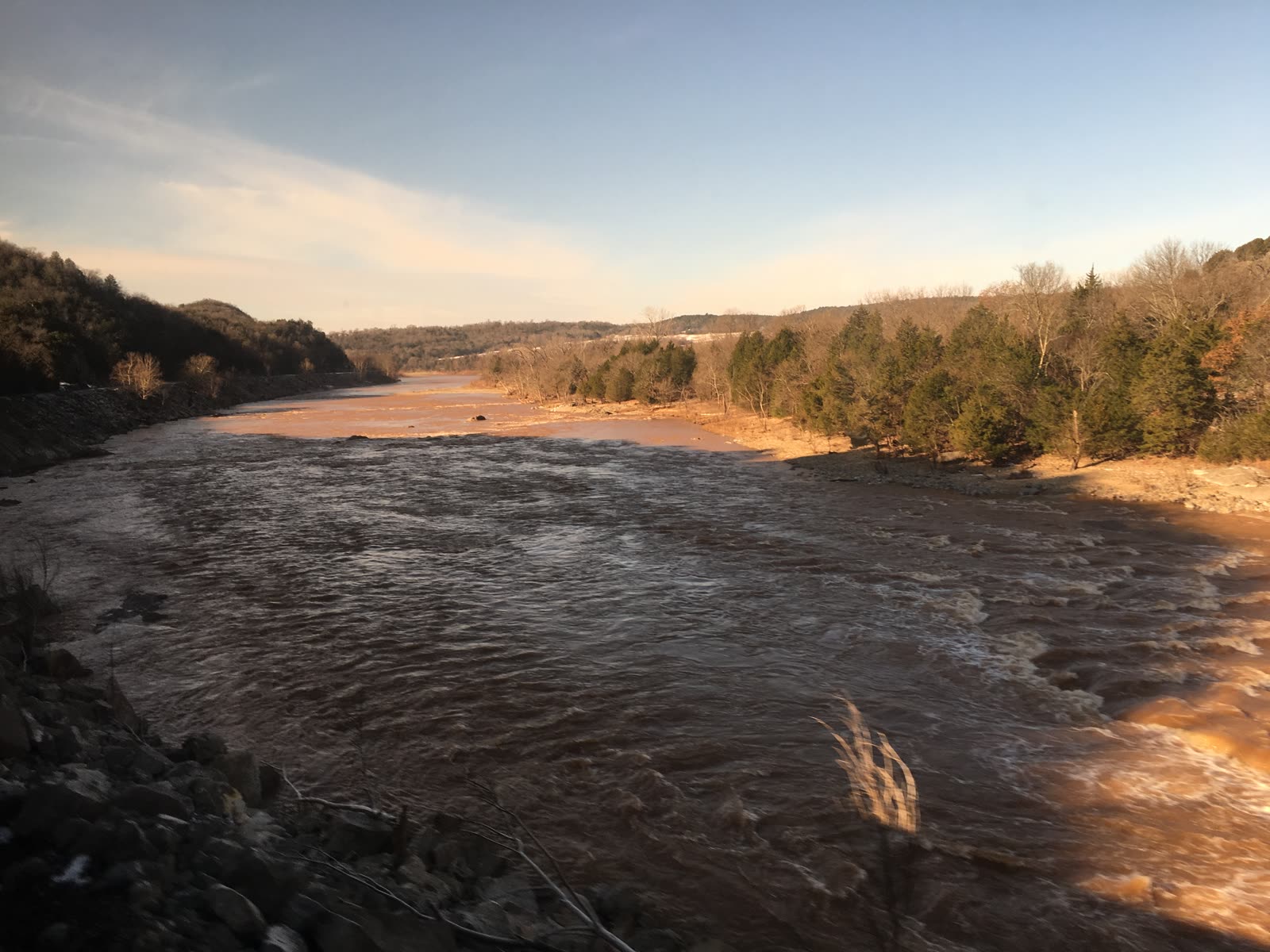
The Red River forms Montague County’s northern boundary for roughly 30 miles, separating Texas from Oklahoma. It is a Plains river — wide, sandy, shallow, salty, broadly meandering, prone to flash flooding and drought-driven low flow. It looks nothing like the clear-running streams of the Hill Country or the deep navigable rivers of East Texas. It looks like itself: a half-mile of sandbars and shifting channels under a wide sky, running red-brown with suspended Permian sediment, surprising visitors from wetter parts of Texas who expect something more dramatic and impressing everyone else as exactly what it is — the geographic anchor of this corner of the state.
The River’s Character
The Red River in MoCo’s reach is not navigable by commercial vessels. During low flow — common in late summer and dry years — the main channel may be only a few feet deep, with extensive sandbars exposed and multiple braided side channels. During flood events, the river fills its floodplain bank-to-bank, rises rapidly after Plains thunderstorm runoff, and rearranges its own channel. The river’s bed is dynamic in a way that fixed-channel rivers elsewhere are not.
Salinity is the Red River’s most distinctive chemical character. Upstream Permian-age salt deposits in the Texas Panhandle and Oklahoma dissolve into the river through salt springs and seeps, contributing substantial sodium chloride loads. The result: the Red River in MoCo’s reach is saltier than typical Texas rivers, though fresher than the headwater reaches above. Salt-tolerant native fish species reflect this — plains killifish, Red River pupfish in some pools, salt-tolerant minnow species alongside the channel catfish and longnose gar that characterize Plains rivers generally. See native fish for the full species picture.
Sediment runs heavy — both the natural sand-bed dynamics of a wide, energetic Plains river and the agricultural runoff contribution from the watershed above. The reddish-brown color that named the river comes from Permian red-bed iron oxide washing in from the Oklahoma and Texas Panhandle tributaries.
Salt-control engineering projects upstream — targeting the Permian salt springs in the Wichita River and Pease River headwaters — have reduced peak salinity over recent decades. The river in MoCo’s reach is cleaner chemically than it was a half-century ago, though still saltier than the Trinity or Sabine.
The Riparian Corridor
The Red River bottomlands form the most ecologically diverse ribbon in an otherwise dry-prairie and Cross Timbers landscape. Within a few hundred yards of the main channel, the vegetation shifts entirely:
Eastern cottonwood (Populus deltoides) is the dominant tall tree — fast-growing, with triangular leaves that flutter in any breeze, a reliable indicator that a watercourse runs permanently enough to support them. The cottonwood-lined river corridor is visible for miles across the surrounding open country.
Bois d’arc (Maclura pomifera) is native to the Red River drainage; Montague County is within its home range. Plains peoples traveled long distances to source bow staves from these trees. Native pecan groves line the terrace zones. Black willow, hackberry, bur oak, and cedar elm round out the gallery forest. See native trees for full species detail.
Salt cedar / tamarisk (Tamarix spp.) has invaded much of the western Red River corridor and is present in MoCo’s reach. It tolerates saline soils, outcompetes native cottonwoods and willows, concentrates salt in the soil through its leaf litter, and burns hot — increasing wildfire risk in the gallery forest. Control requires sustained mechanical and chemical effort. It is the primary ongoing threat to the bottomland hardwood community.
Wildlife of the Corridor
The bottomland corridor concentrates wildlife at densities the surrounding upland cannot match:
Bald eagles winter on the river in notable numbers, using cottonwoods as roost trees and open water for fishing. Some breeding pairs have established in recent years. Winter is the best season to see them.
Wood ducks nest in bottomland cavities year-round where suitable trees exist. Great blue herons, great egrets, green herons, and black-crowned night-herons fish the river shallows and oxbow pools. Wild turkey roost in cottonwoods along the bottoms and forage into adjacent prairie.
Prothonotary warblers, summer tanagers, and yellow-billed cuckoos are bottomland breeders in summer. The migratory bird story is larger and is covered in the migratory birds file — the Red River corridor is part of the Central Flyway.
White-tailed deer are dense in the bottomlands. Beaver are present along the river and major tributary creeks. River otter populations have recovered. Feral hogs are especially destructive in river-bottom habitat — rooting up vegetation, destabilizing banks, and consuming ground-nesting bird eggs.
Softshell turtles — particularly the Texas spiny softshell (Apalone spinifera emoryi) — are common in the river, buried in sandy bottoms. Snapping turtles and water snakes occupy the slower pools and backwaters.
Human History Along the River
The Red River corridor concentrates the county’s deepest human history as completely as it concentrates its wildlife.
Taovaya villages at Spanish Fort and nearby sites were the northernmost agricultural settlements of the Wichita-Caddoan peoples — farming corn, beans, squash, and sunflowers in the fertile bottomland, trading bois d’arc bow staves, and dominating the Red River trade network in the 18th century.
Red River Station was a Confederate fortification established in 1861 that became, after the Civil War, one of the principal Chisholm Trail crossings — an estimated 2.4 to 5.2 million head of cattle crossed the Red River at this general location during the trail’s peak years in the 1870s and 1880s. Drovers timed crossings for low-water periods; quicksand was a documented hazard. See Red River Station for the full history.
Illinois Bend, the Red River settlement raided in December 1863, and Spanish Fort, the trail-town that grew on the Taovaya village site, are both landmarks of the same corridor — the river that everything and everyone in this county’s history has crossed, avoided, depended on, or been defined against.
Water Rights and Administration
Red River water rights in Texas are administered by the Texas Commission on Environmental Quality under the prior-appropriation framework. The Red River Compact governs water-sharing between Texas, Oklahoma, Arkansas, and Louisiana for the basin as a whole. The river’s saline character has historically constrained direct diversion for municipal use — which is part of why MoCo’s municipal water supply depends on the fresher-water tributary reservoirs (Lake Nocona on Farmers Creek, Lake Amon G. Carter on Big Sandy Creek) rather than direct Red River diversion. See water rights and irrigation for the full framework.
Modern Use and Conservation
Recreational access to the Red River in MoCo is limited primarily by private land ownership along the banks. Fishing — catfish, gar, white bass — is the main draw where access exists. Duck and goose hunting along the river edges is seasonal. Bowfishing for gar and carp is practiced. Kayak and canoe use is possible at moderate flow; floating the river requires navigating sandbars and side channels rather than a straightforward current.
Sand and gravel operations have historically worked some reaches of the river bed. Bank erosion and channel migration are ongoing concerns for landowners with riverfront property.
The River’s Role
For Montague County, the Red River is simultaneously a state boundary, a cultural marker, a wildlife corridor, and a historical stage. The phrase “across the river” in local conversation means Oklahoma — and carries connotations of crossing a threshold, of the frontier that ran along this line for decades before it was settled. The bald eagles in the winter cottonwoods, the bois d’arc trees that supplied Plains bow staves, the Chisholm Trail crossings, the Taovaya villages — all of it belongs to the river corridor. No other feature of the county concentrates this county’s story so completely.
See also: native fish for the aquatic species inventory, migratory birds for the flyway context, and denton-creek watershed for the county’s southward drainage.