Stand on the south bank of the Red River at Spanish Fort and look north. The river is wide here, sandy, crossable at the right season on horseback. The bottomland timber on both banks — cottonwood, pecan, black willow — gives concealment for an approach. The terrain opening to the south leads through Cross Timbers prairie corridors toward the settler communities of Cooke, Wise, Denton, and Tarrant counties, and if a force moved fast enough, further still — into the Hill Country, into Mexico.
For roughly three decades, from the late 1840s until 1875, Comanche and Kiowa raiding parties used these crossings. Montague County sat on the eastern edge of Comanchería — the vast territorial domain the Comanche had controlled across the southern Plains since roughly the early 1700s — and the Red River corridor here was both transit zone and target. What happened along this stretch of river is not a footnote to Montague County’s history. It is the central event of its first quarter-century of Anglo-American settlement.
Source note: All accounts of raid routes, force composition, and MoCo-specific incidents are drawn from Anglo-Texan settler records, county histories, and TSHA documentation. Comanche and Kiowa oral tradition on the raid era — the Indigenous account of the same events — has not been consulted for this file; engagement with the Comanche Nation THPO and the Kiowa Tribe of Oklahoma THPO is required before those perspectives can be incorporated. The settler record presents one perspective on a conflict that both sides understood and remember differently.
Why Did the Route Run Through Montague County?
Several geographic facts converged to make MoCo a natural raiding corridor:
The Red River crossings
The Red River separating Texas from Indian Territory offered only intermittent reliable crossings. A raiding party moving south needed shallow, fordable water with sandbar approaches and concealment from military patrols. The northern reach of Montague County provided several usable fords:
- Spanish Fort — in use as a river crossing by Plains peoples for centuries before Anglo settlement. The shallow approach, the historic familiarity of the site, and the bottomland concealment made it a default crossing point.
- Red River Station — roughly nine miles northwest of modern Nocona, a crossing that the Confederate Frontier Regiment attempted to monitor from 1861 onward, with variable effectiveness.
- Illinois Bend — at the long eastward curve of the river in MoCo’s northeastern corner, where the bottomland topography offered both workable fords and concealment from the upland.
The Cross Timbers corridors
The Cross Timbers — the two broken bands of oak and elm woodland running north-south through this part of Texas — defined the raiding corridor’s eastern boundary. Between and alongside these timber bands ran open prairie strips where mounted raiders could move quickly. The timber edges provided concealment for camps, ambush positions, and hidden approaches. The prairie provided speed.
The distance from Texas military posts
The established military posts of the 1850s–1870s frontier — Fort Belknap, Fort Griffin, Fort Richardson — were further west. The older settled communities with their Texas Ranger and state militia presence were further east. Montague County sat in a gap between the two lines of protection, a corridor where, for most of the conflict era, neither the western forts nor the eastern defenses could provide reliable coverage.
The Great Comanche War Trail
Anglo-Texan sources referred to the major north-south raiding corridor through this region as the Comanche Trail or, in some accounts, the Great Comanche War Trail — though there were multiple such trails across the southern Plains, and the label covered a general pattern of routes rather than a single identified path. The corridor running through the southern Cross Timbers and MoCo’s region was one of the most consistently used in the documented conflict era.
From the Red River crossings in northern Montague County, the main southward movement routes tracked:
- Salt Creek and Farmers Creek drainages — water sources and concealment for camped parties
- Cross Timbers brush edges — cover for ambush positions and overnight camps
- Open prairie ground — fast movement on horseback between cover positions
The routes didn’t stop at the Cooke-Montague county line. They continued south through Cooke County, Wise County, Denton County, and Tarrant County — and in the largest raids, further still into central Texas and south toward the Rio Grande, with some raids documented as reaching into Mexico.
Montague County was both a transit zone and a target. Homesteads in the county’s northern tier were attacked in their own right; other raids moved through MoCo on their way to communities further south.
How Raids Were Organized
Timing: The Comanche Moon
Most documented raids occurred in the cooler months — fall through early spring. Night movement was the preferred operational pattern for crossing rivers and approaching homesteads: the cover of darkness reduced the warning time available to settlers.
The full or near-full moon in autumn — when the weather was cool enough for extended travel, the grass still adequate for horses, and the moonlight bright enough for night riding — became known among Anglo-Texan settlers as the “Comanche Moon.” It entered Texas vocabulary as a phrase for the specific season of maximum raid danger, and it was not metaphor. Raid frequency in the documented record peaks in the fall and early winter months.
Force sizes
The documented raid pattern ran across a wide range of force sizes:
- Small parties — 5 to 20 warriors, targeting isolated stock and travelers; the most common pattern, continuous through the entire era
- Medium parties — 20 to 50 warriors, for organized operations against specific farmsteads or road corridors
- Large raids — 100 to 250-plus warriors, rare major operations combining multiple bands; the December 1863 Illinois Bend raid, at roughly 250 warriors, was the largest documented MoCo event
Tactical pattern
The standard operational approach:
- Stealthy crossing of the Red River, usually at night or in pre-dawn hours
- Movement south through prairie corridors, avoiding known patrol routes
- Sudden attack on dispersed target homesteads in coordinated spread — designed to prevent one farmstead from warning the next
- Quick dispersal with captives, livestock, and taken property
- Withdrawal north in spread formation to complicate pursuit
- Reassembly at predetermined points
- Crossing back into Indian Territory, where Texas pursuit had no jurisdiction
The dispersal-on-withdrawal was particularly effective. Pursuit parties typically found themselves chasing multiple separated groups, any of which might be the main force, with no reliable intelligence on which trail to follow.
Documented Raid Events in Montague County
December 1863 — Illinois Bend
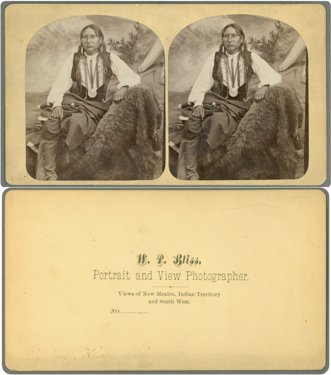
The largest and most documented single raid in Montague County’s history. Approximately 250 Kiowa and Comanche warriors crossed from Indian Territory into the Illinois Bend community on the Montague-Cooke County line, killing at least a dozen settlers, taking captives, and withdrawing north with livestock. Anglo-Texan sources attribute the raid to Kiowa war chief Big Tree (Adoeette) — the tribal identification is Kiowa, not Comanche, per TSHA Handbook and Kiowa tribal sources. The raid’s scale was made possible by Civil War depletion of frontier defenses. Full account: The 1863 Illinois Bend Raid.
September 5, 1870 — Denton Creek
A Denton Creek ambush killed settler families. Sources document this event but do not confirm specific attacker identification. This incident is significant in the Ann Keenan historical record: available genealogical and regional sources associate Ann Keenan’s and Mrs. Paschal’s deaths with this September 5, 1870 event — not the December 1863 raid, though some accounts conflate the two. Primary-source verification is pending.
Pattern through the 1860s–1870s
Beyond these two named events, Mrs. W.R. Potter’s 1913 History of Montague County documents a sustained pattern of violent incidents through the 1860s and into the 1870s involving the Wainscot, Spencer Moore, Box, Shegog, Parkhill/Fitzpatrick, McElroy, Leatherwood, Powers, Keenan, Paschal, Brake Green, and Billy Bailey families. The cumulative casualty count across the MoCo conflict era reaches into dozens, and possibly higher when smaller and undocumented incidents are included.
The Settler Experience
For a family farming in MoCo’s northern tier through the 1850s and 1860s, the raid era was not a background condition. It was the condition. Every missing horse was a potential raid sign. Every night during Comanche Moon season was a potential raid night.
Settlers adapted through:
- Fortified positions — thicker walls, gun ports, stockade fencing, and communal refuges like Fort Illinois Bend where families could shelter
- Watch routines — community lookout posts and signal systems
- Mutual response — neighbors riding to aid when an attack occurred at distance
- Strategic withdrawal — many families left and returned multiple times; permanent evacuation was common at different points in the era
The 1860 census counted 849 MoCo residents. The 1870 census found 890. That flat decade conceals a real trough, probably deepest around 1867, when much of the northern county was functionally evacuated.
The End of the Raid Era
The collapse of the raiding system was rapid once the enabling conditions were removed:
- 1872 onward — increased federal military pressure on Comanche-Kiowa bands
- 1872–1878 — hide hunters destroyed the southern bison herd, eliminating the subsistence base that supported Plains military capacity (see: Buffalo Hunters on the Red River)
- 1874 — Red River War — coordinated US Army campaign across the southern Plains
- September 1874 — Battle of Palo Duro Canyon — Colonel Mackenzie destroyed the Comanche horse herds and winter supplies; this, not battlefield casualties, broke the Comanche military capacity
- 1875 — Final surrenders; Comanche and Kiowa peoples confined to Fort Sill reservation
- 1875–1876 — Raids from the MoCo corridor effectively ceased
Within a few years, families were returning to the abandoned farmsteads of MoCo’s northern tier. The population that had been essentially flat through the entire war and raid decade began to grow. The county’s cotton and cattle era — the phase that would define its economic identity through the late 19th century — could only begin when the raid corridor had been closed.
The Legacy in the Landscape
The raid era left marks that are still visible in Montague County’s geography and memory:
- Spanish Fort — the place name preserves the memory of the Red River crossing point used for centuries, including through the conflict era
- Illinois Bend — the community name is inseparable from the 1863 raid in county historical memory; the cemetery holds some of the era’s casualties
- Red River Station — the Frontier Regiment post whose location marks the military geography of the conflict
- Tales ‘N’ Trails Museum (Nocona) and Stonewall Saloon Museum (Saint Jo) — collections with frontier-era artifacts and documentation
- Mrs. W.R. Potter’s 1913 History — the primary settler-era account of raid casualties and family experiences
The Comanche Nation and the Kiowa Tribe of Oklahoma hold accounts of the same era from their nations’ perspectives. Consultation with their cultural offices — the Comanche Nation THPO and the Kiowa THPO — is the appropriate path for adding the Indigenous side of this history to MoCo’s public record.
Related pages: The 1863 Illinois Bend Raid · The Civil War on the Frontier · Buffalo Hunters on the Red River · Illinois Bend · Texas Rangers in Montague County · Frontier Era Index
Sources: TSHA Handbook of Texas (“Red River War,” “Battle of Palo Duro Canyon,” “Big Tree,” “Warren Wagontrain Raid”); Hämäläinen, The Comanche Empire (Yale, 2008); Mrs. W.R. Potter, History of Montague County (1913); Comanche Nation (comanchenation.com); Kiowa Tribe of Oklahoma (kiowatribe.org). Comanche and Kiowa oral tradition on the raid era requires direct tribal consultation before it can be incorporated.