Before the Comanche, before the Spanish, before any Anglo-American eye saw the Red River corridor of north Texas, the Wichita-Caddoan peoples had been farming its river bottoms, building its fortified towns, and trading its resources for generations. Their most significant settlement in Montague County’s region — the Taovaya village at Spanish Fort — was one of the major population centers of 18th-century interior North America, a place sophisticated enough in its fortifications and military capacity to defeat a 600-man Spanish expedition in 1759.
Their descendants are the Wichita and Affiliated Tribes, headquartered today in Anadarko, Oklahoma. This is their ancestors’ story.
Tribal consultation pending. Taovaya/Wichita village genealogy, named leaders, and oral tradition await review by the Wichita and Affiliated Tribes. Claims here draw from Spanish colonial records, TSHA scholarship, and Texas Beyond History archaeological work; they reflect what those sources documented, not the Wichita people’s own account of their history.
1. Who the Wichita-Caddoan Peoples Were
Language and Cultural Family
The Wichita peoples are Caddoan-language speakers, part of the same broad linguistic family as the Caddo Confederacy of east Texas, the Pawnee of the central Plains, the Arikara of the upper Missouri, and the Kitsai. The Caddoan language family is one of the older established families of the North American interior, with a geographic range running from the Red River drainage north through Kansas and Nebraska. The Wichita language is no longer spoken fluently; it survives in archival materials and through active revitalization efforts maintained by the tribe.
The designation “Wichita” covers a confederation of related peoples who appear in Spanish and French colonial records under multiple names — terminological confusion in colonial-era primary sources is the rule, not the exception:
- Wichita proper (also Tawehash, Towakoni in some records)
- Taovaya (sometimes Taovayas, Tawehash — the primary group at Spanish Fort)
- Tawakoni
- Waco
- Iscani / Yscanis (Wichita-affiliated; distinct village presence documented in some sources)
- Kichai / Kitsai (closely affiliated; sometimes treated separately)
All of these peoples are now represented under the federally recognized Wichita and Affiliated Tribes.
Village People, Not Nomads
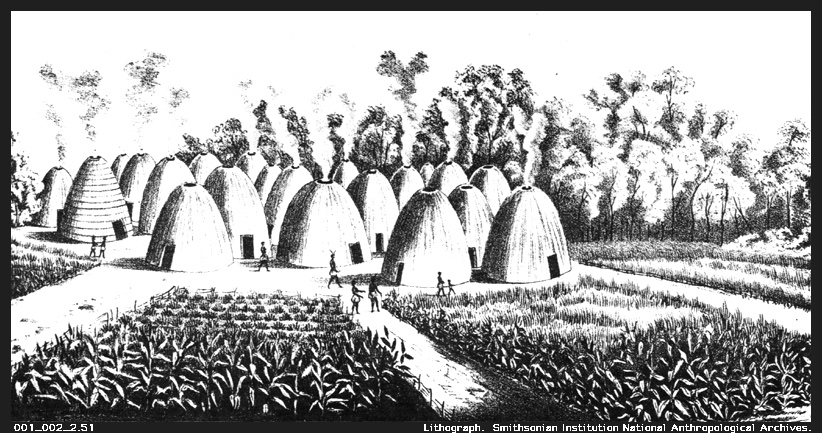
The single most important thing to understand about Wichita-Caddoan peoples — and the thing that Anglo-American settlement narrative most consistently missed — is that they were not nomadic. They were village farmers and town builders, as different from the mobile equestrian Comanche as a city is from a camp.
Wichita lifeways:
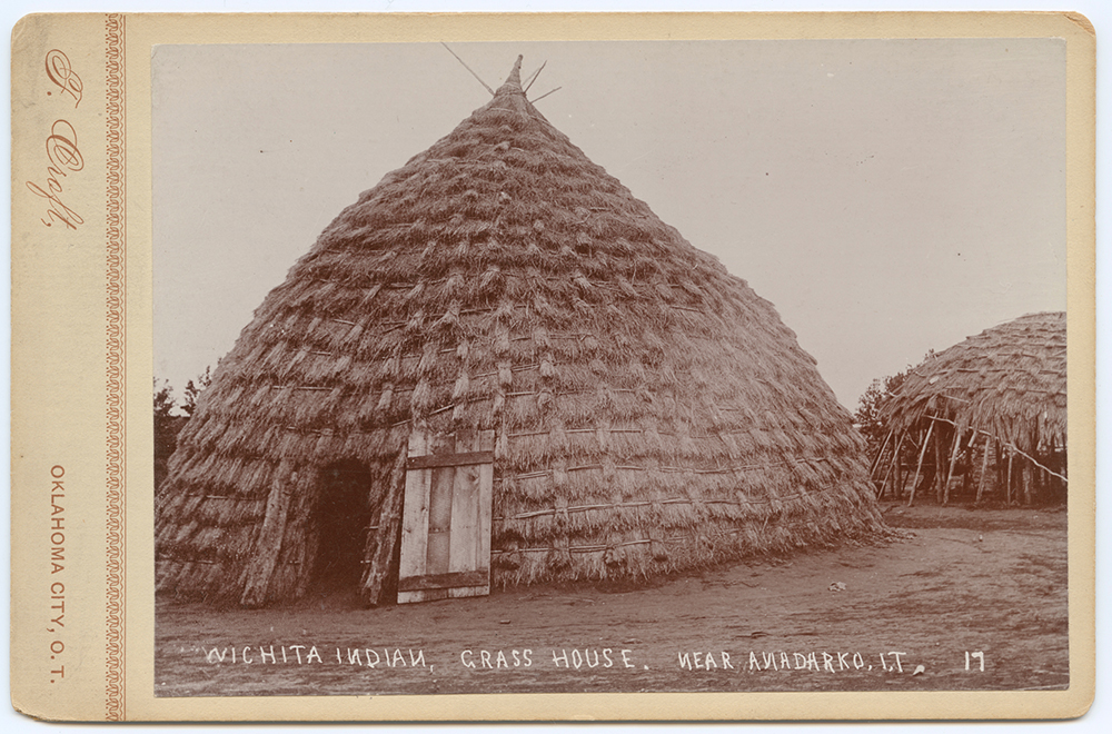
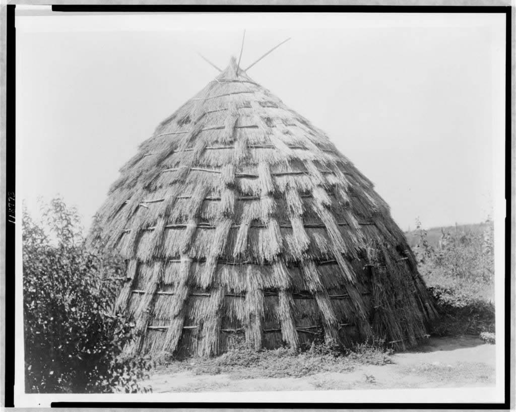
- Permanent villages of grass-thatched dome lodges, 30 to 50 feet across, with central hearths and sleeping berths around the interior walls
- Agricultural fields of corn, beans, squash, and sunflowers — the “Three Sisters” crop complex plus sunflower, all cultivated in river-bottom soil
- Seasonal buffalo hunts — bands left villages periodically for plains hunting, returning for harvest and winter
- Trade economy linking the southern Plains, the Pueblo Southwest, and the Mississippi Valley
- Fortified village complexes — palisaded towns with earthworks and defensive ditches, especially in the 18th-century contact period when mounted enemies required defensive innovation
This agricultural, village-centered way of life had been established along Red River drainages for generations before Spanish or French colonial records document it. The earthworks at Spanish Fort are not military construction — they are the defensive architecture of a town.
[TSHA Handbook of Texas. “Wichita Indians.” tshaonline.org. Retrieved 2026-05-06.] [Newcomb, W. W. (1961). The Indians of Texas: From Prehistoric to Modern Times. University of Texas Press. pp. 150–175.]
2. Geographic History — The Long Migration South
The Wichita peoples have moved geographically across centuries in response to successive waves of pressure.
Before European Contact (pre-1540)
The deepest roots of Wichita-Caddoan peoples in the Plains date to pre-contact centuries. Spanish entradas first documented Wichita-affiliated peoples when Coronado’s 1541 expedition reached “Quivira” — a Wichita-related region in central Kansas, probably near present-day Great Bend. The peoples Coronado found were already village farmers with grass-thatched dome lodges, cultivated fields, and established trade networks. This was not a new civilization; it was an old one that Spanish records had just caught up with.
Southward Pressure (1600s–1700s)
Through the 17th and early 18th centuries, Wichita-Caddoan peoples shifted southward under pressure from two directions. Osage expansion from the north and east pushed them out of central Kansas; Apache pressure and later Comanche expansion from the west and south constrained where they could go. The result was a southward consolidation along the Red River and Arkansas River drainages — exactly the corridors that would put Wichita-Caddoan peoples directly at the intersection of Spanish and French imperial ambitions.
The Spanish Fort Village (ca. 1750)
By the early 1750s, the Taovaya — the most politically significant Wichita-affiliated group — had established twin fortified villages on the Red River: a north-bank village in present-day Jefferson County, Oklahoma, and a south-bank village at what is now Spanish Fort in northern Montague County, Texas. This paired “twin villages” arrangement, referenced in later historiography, likely reflected kinship or political divisions within the Taovaya community positioned for mutual defense.
[Smith, F. T. (2000). The Wichita Indians: Traders of Texas and the Southern Plains, 1540–1845. Texas A&M University Press. pp. 68–95.] [Texas Beyond History. “Spanish Fort: A Taovaya Village on the Red River.” texasbeyondhistory.net. Retrieved 2026-05-06.]
3. The Spanish Fort Village — Fortifications and Daily Life
The Taovaya village at Spanish Fort was substantial by any measure. Spanish colonial records — which scholars note may overestimate figures for rhetorical effect — describe a settlement with thousands of people and defensive architecture that surprised the Spanish expedition of 1759.
Architecture
The village’s grass-house lodges were distinctive: circular structures 30 to 50 or more feet in diameter, built with a central pole frame, covered in thatch laid from base to peak in overlapping courses, with a central hearth and sleeping bunks arranged around the interior walls. These were not temporary shelters but permanent residences that could accommodate extended family groups through a full seasonal cycle.
The defensive architecture was more than a fence. Archaeological investigation has confirmed earthen berms, a double-walled wooden palisade incorporating both vertical and horizontal timber elements reinforced with packed earth, and a defensive moat. These are the features of a military wall — designed to resist assault from mounted enemies and withstand projectile fire from the same French-supplied muskets the Taovaya defenders used themselves.
Agriculture
The river bottoms below the bluff supported cultivated fields of corn, beans, squash, and sunflowers. This agricultural base was the foundation of the Taovaya trade economy: surplus grain, dried beans, sunflower seed oil, and melons moved outward in exchange for horses, buffalo products, and — through the French trade network — European manufactured goods. The Taovaya controlled a food-producing site in a landscape of mobile hunter-gatherers, which gave them a structural trade advantage.
The Trade Hub
The Spanish Fort village was more trade center than fortress. French traders working up the Red River from Louisiana posts supplied firearms, iron tools, wool cloth, and glass beads. Comanche bands from the High Plains arrived with horses and buffalo robes. The Taovaya sat at the hub, taking a trade margin from both directions and supplying each with what the other produced. This trade triangle made Spanish Fort one of the most commercially significant locations in the 18th-century interior.
The firearms this trade delivered made the Taovaya the best-armed people in the southern Plains at a moment when Spain was trying to extend military authority into the region.
[Smith, F. T. (2000). The Wichita Indians. pp. 80–95.] [Wichita and Affiliated Tribes. “Our History and Culture.” wichitatribe.com. Retrieved 2026-05-06.]
4. The 1759 Victory Over Spain
Why Spain Came to Spanish Fort
The Spanish expedition of 1759 was retaliation for the March 1758 destruction of Mission Santa Cruz de San Sabá near present-day Menard County. A coalition force of approximately 2,000 warriors — Comanche, Taovaya and Tawakoni Wichita-Caddoan peoples, Tonkawa, and others — had destroyed the mission and killed its Franciscan missionaries. Colonel Diego Ortiz Parrilla assembled a force of approximately 600 men to punish the Taovaya village, which Spain identified as central to the coalition.
October 7, 1759
Parrilla’s force arrived at the Spanish Fort village on October 7, 1759, with two fieldpiece cannon he expected to use decisively against what his intelligence said was an unfortified settlement. The Taovaya had prepared: earthen walls, a double palisade, a defensive moat, and French firearms in the hands of defenders who had been using them for years. A French flag flew over the fortification — a deliberate declaration of alliance and a message to the Spanish column about what they would face.
The Spanish cannon fired for four hours. The palisades held. Defenders returned fire with muskets. Comanche cavalry occupied the approaches and flanks throughout the engagement. By the time Ortiz Parrilla ordered retreat, the expedition had lost at least 19 killed and 14 wounded. Both cannon were abandoned — captured by the Taovaya.
The Spanish never attempted a military expedition against Wichita-Caddoan peoples in Texas again. The defeat at Spanish Fort ended that strategy permanently.
For the full military narrative, see Battle of the Twin Villages.
[TSHA Handbook of Texas. “Ortiz Parrilla Red River Campaign.” tshaonline.org. Retrieved 2026-05-06.] [Texas Beyond History. “Spanish Fort: A Taovaya Village on the Red River.” texasbeyondhistory.net. Retrieved 2026-05-06.]
5. The Long Decline — Disease, Comanche Pressure, and Removal
Epidemic Disease
Smallpox moved through the southern Plains in multiple waves across the 18th and 19th centuries. NRHP documentation for the Spanish Fort Site notes smallpox epidemics beginning in 1778 as a major factor in Taovaya village decline. An 1801 epidemic was particularly severe across the broader Plains region. Cumulative population estimates for Wichita peoples show an 80 to 90 percent decline from pre-contact levels through the early 19th century — a demographic catastrophe that progressively hollowed out the village that had successfully held off a Spanish army.
Comanche Pressure
The Comanche-Wichita relationship that had been an alliance of mutual advantage through the 18th century shifted as Comanche expansion consolidated control of the southern Plains. The Comanche increasingly occupied former Wichita agricultural territory; the Taovaya village, which required defensible river-bottom land and proximity to trade networks, found its strategic position eroding as Comanche population and military capacity grew.
By the early 19th century, the Spanish Fort village had been largely abandoned. NRHP documentation places the final abandonment at approximately 1841.
Federal Removal
The political end came in 1859. Federal pressure forced Wichita-affiliated peoples from their last Texas settlements into Indian Territory (present-day Oklahoma). The Civil War created further disruption, displacing Wichita peoples north into Kansas before they returned to Oklahoma after the war. By 1865, no Wichita-affiliated communities remained anywhere in Texas.
[Smith, F. T. (2000). The Wichita Indians. pp. 140–185.] [National Register of Historic Places. Spanish Fort Site listing. NRIS 75002000. Listed April 14, 1975.]
6. The Misnaming Problem
Spanish Fort was never a Spanish military post. The site is a Taovaya village that successfully repelled Spanish forces in 1759. The name appears to have originated with Anglo-American settlers who arrived in the mid-19th century, found the earthwork ruins on the Red River bluff, and assumed they had been built by Spanish soldiers — or applied “Spanish” loosely as a label for any pre-Anglo earthwork in the region.
The result of this naming accident is that the most significant Indigenous military victory in 18th-century Texas is commemorated by a place name that erases the victors and credits their enemy. The Texas Beyond History program at the University of Texas at Austin has documented this misnaming in its Spanish Fort site resources; the Texas Historical Commission marker on FM 103 — titled “Site of the 1759 Taovayo Victory Over Spain” — partially corrects the public record in physical signage.
[TSHA Handbook of Texas. “Spanish Fort, Texas.” tshaonline.org. Retrieved 2026-05-06.] [Texas Beyond History. “Spanish Fort: A Taovaya Village on the Red River.” texasbeyondhistory.net. Retrieved 2026-05-06.]
7. Material Culture
Wichita material culture before forced removal included practices and objects that persist in modified form among the modern Wichita and Affiliated Tribes:
- Grass-thatched dome lodges — the distinctive architectural form of Wichita settlement; the large communal houses that gave the “Wichita” peoples their name among English speakers
- Pottery — distinctive Wichita ceramic traditions
- Leather and hide work — tanned hides for clothing, robes, and carrying containers
- Long bows — Wichita archers were renowned; bois d’arc bow staves were a significant trade commodity
- Extensive tattooing — face and body tattoos in gendered patterns, documented in Spanish and French sources as a Wichita cultural marker
- Pipes and tobacco — ceremonial and social use
- Dance and ceremonial cycles — agricultural and hunting ritual life tied to seasonal rhythms
8. The Modern Nation — Wichita and Affiliated Tribes
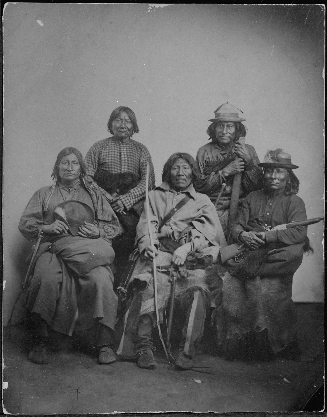
The federally recognized Wichita and Affiliated Tribes are headquartered at Anadarko, Oklahoma. Current enrolled membership exceeds 3,000 people. The tribal government operates cultural preservation programs, language revitalization efforts, economic enterprises, and maintains tribal services for enrolled members in and outside the jurisdictional area.
The tribe holds authoritative cultural knowledge of the Spanish Fort village complex and the broader Taovaya heritage. Tribal consultation pending — nothing here should be read as the final word on a history the Wichita and Affiliated Tribes know better than any secondary source.
[Wichita and Affiliated Tribes. “Our History and Culture.” wichitatribe.com. Retrieved 2026-05-06.] [TSHA Handbook of Texas. “Wichita Indians.” tshaonline.org. Retrieved 2026-05-06.]
See Also
- Battle of the Twin Villages — Full military narrative of October 7, 1759
- Old Spanish Fort — The site’s archaeological heritage and Anglo settlement layers
- Spanish Fort — The Chisholm Trail ghost town community
- Spanish–French Imperial Rivalry — The imperial competition that armed the Taovaya
References
[National Register of Historic Places. Spanish Fort Site listing. NRIS 75002000. Listed April 14, 1975.]
[Newcomb, W. W. (1961). The Indians of Texas: From Prehistoric to Modern Times. University of Texas Press.]
[Smith, F. T. (2000). The Caddo Indians: Tribes at the Convergence of Empires. Texas A&M University Press.]
[Smith, F. T. (2000). The Wichita Indians: Traders of Texas and the Southern Plains, 1540–1845. Texas A&M University Press.]
[Texas Beyond History. “Spanish Fort: A Taovaya Village on the Red River.” University of Texas at Austin. texasbeyondhistory.net. Retrieved 2026-05-06.]
[Texas State Historical Association. “Ortiz Parrilla Red River Campaign.” Handbook of Texas Online. tshaonline.org. Retrieved 2026-05-06.]
[Texas State Historical Association. “Spanish Fort, Texas.” Handbook of Texas Online. tshaonline.org. Retrieved 2026-05-06.]
[Texas State Historical Association. “Taovaya Indians.” Handbook of Texas Online. tshaonline.org. Retrieved 2026-05-06.]
[Texas State Historical Association. “Wichita Indians.” Handbook of Texas Online. tshaonline.org. Retrieved 2026-05-06.]
[Wichita and Affiliated Tribes. “Our History and Culture.” wichitatribe.com. Retrieved 2026-05-06.]