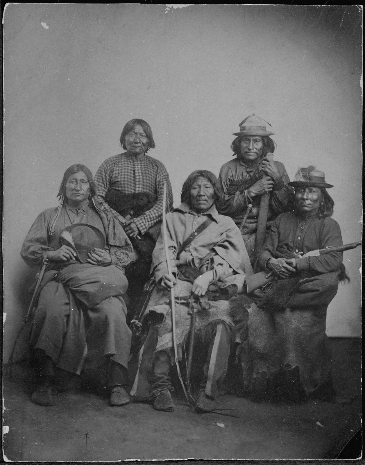
Montague County sits on the eastern edge of what was, for roughly 175 years, Comanchería — the vast territory dominated by the Comanche people, running from the Arkansas River south into Mexico and from the Rocky Mountain foothills east to the Cross Timbers. The frontier conflicts that defined MoCo’s settler experience from 1849 through 1875 were fundamentally a conflict with two nations: the Comanche and the Kiowa, whose alliance had made them the most powerful military force on the southern Plains.
Understanding Montague County before Anglo settlement requires understanding Comanchería. The 30-year frontier conflict era that saturates early settler accounts was the final phase of a much longer and larger story. This page is that story.
Comanche and Kiowa histories are well documented in scholarly literature. Tribal consultation pending — raid attributions and territory claims here draw on Anglo-settler and US Army records; corresponding Comanche and Kiowa oral-tradition accounts require review by the Comanche Nation and Kiowa Tribe of Oklahoma.
Tribal ID note: Satanta (White Bear) and Satank were Kiowa leaders. Big Tree (Adoeette) was also Kiowa, not Comanche — a correction confirmed in research from prior passes. Where earlier Anglo-settler accounts misattributed Kiowa individuals as Comanche (a common error in contemporary records), those attributions are corrected here.
1. Origins and Rise
The Comanche
The Comanche are speakers of a Numic language closely related to Shoshone — linguistically, they were originally a northern Shoshone group living in the Wyoming-Idaho mountain-and-basin region in the early 1600s. Their repositioning onto the southern Plains is one of the great mobility stories in Indigenous North American history.
The mechanism was the horse. The Pueblo Revolt of 1680 and the subsequent dispersal of Spanish horse herds through trade and raiding put horses into Shoshone hands by the early 1700s. A people already adapted to large-territory movement in mountain country, given horses, became something new on the Plains:
- Pre-1700: Northern Shoshone subsistence in Wyoming-Idaho basin-and-range country
- Early 1700s: First horses; first Plains movement
- 1700–1750: Southward expansion onto the southern High Plains; displacement of Apache peoples who had previously dominated the region
- 1750–1800: Consolidation as the dominant power on the southern Plains; Comanchería taking shape
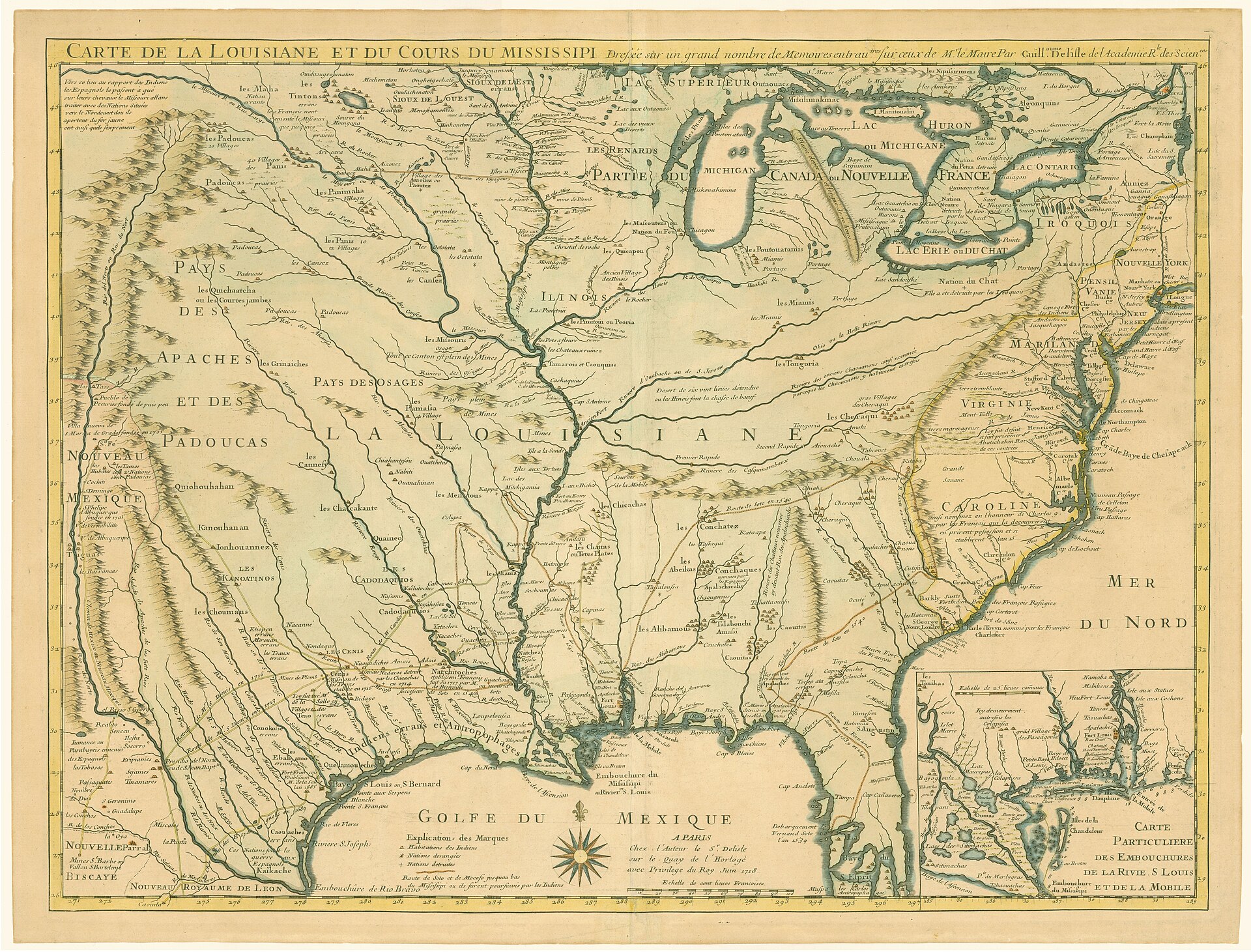
- 1800–1875: Comanchería at full extent — roughly 240,000 square miles of territory, from central Kansas to northern Mexico
The transformation from mountain Shoshone to mounted southern Plains power within two generations is one of the most successful Indigenous adaptations to European-introduced technology in the Americas.
Comanche Bands
Comanche peoples organized into multiple bands — related by language and culture but operationally independent, sometimes with different relationships to Spanish, Mexican, Texan, and US authorities:
- Kotsoteka (Buffalo Eaters)
- Penateka (Honey Eaters) — southernmost band; closest to the Texas frontier and earliest to experience Anglo pressure
- Yamparika (Yap Eaters / Root Eaters) — northernmost
- Quahadi / Quahadie (Antelope) — westernmost; Quanah Parker’s band; held out longest in resistance
- Nokoni (Wanderers / Returners) — Peta Nocona’s band; active in MoCo’s region and the wider Red River corridor
The Kiowa
The Kiowa speak a Tanoan-related language with no close relatives among other Plains peoples. They emerged on the southern Plains in the early-to-mid 1700s, moving from origins in the upper Missouri and Yellowstone region southward:
- Origins in the upper Missouri / Yellowstone region
- Southward movement onto the southern Plains through the 1700s
- Comanche-Kiowa alliance formalized roughly 1790 — a foundational political arrangement that held for nearly a century
- Parallel lifeways — mounted buffalo hunting, raiding economy, kin-based band organization
The Kiowa-Apache (or Plains Apache) were a small Athapaskan-speaking band politically aligned with the Kiowa despite their linguistic distinctness — one of several anomalies that complicated 19th-century attempts to map people onto tidy tribal categories.
2. Comanchería — What It Was
At its largest extent (roughly 1830–1860), Comanchería included:
- All of the Texas Panhandle and Llano Estacado (Staked Plains)
- Much of west-central Texas
- The Rolling Plains and northern Cross Timbers
- Eastern New Mexico
- Western Oklahoma
- Southwestern Kansas
- Northern Mexico — raiding zones extending south of the Rio Grande
Montague County was on the eastern edge of Comanchería — the contact zone between Comanche and Kiowa dominance and the encroaching Anglo-Texan settlement frontier. This geography made the county a primary raiding corridor and contested ground from the moment Anglo settlers arrived.
3. Lifeways
Comanche and Kiowa lifeways in the 18th and 19th centuries were functionally parallel — both built around mobility, the buffalo, and the horse:
Mobility
- Tipi-based households — buffalo-hide portable lodges that could be raised or struck in under an hour
- Seasonal camp movement following buffalo herds across the Plains
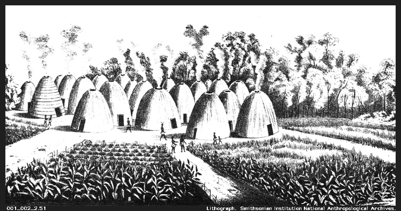
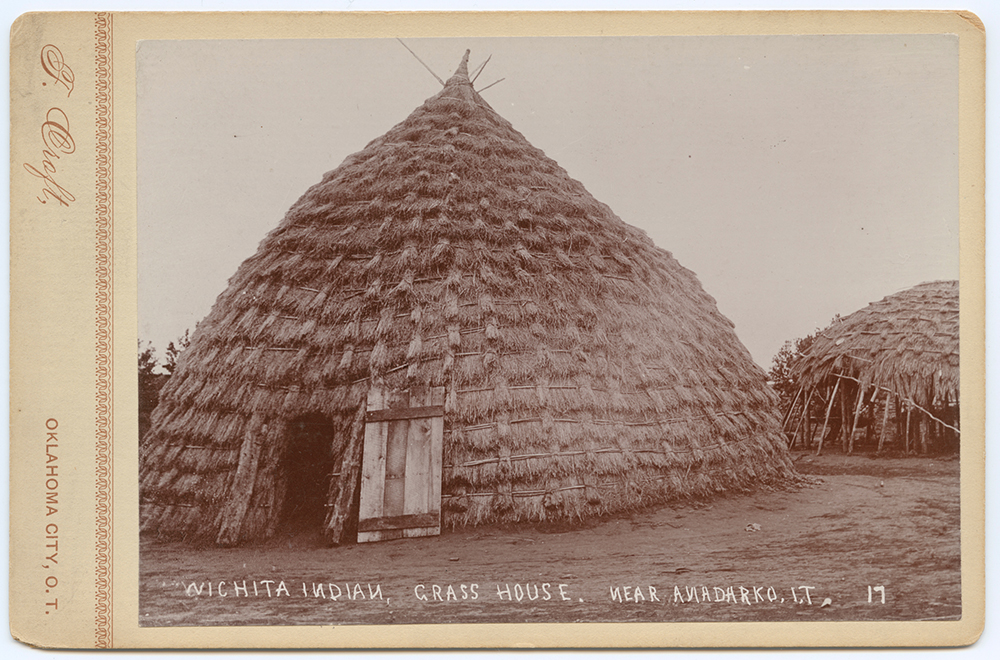
- No permanent villages — the fundamental contrast with the Taovaya/Wichita agricultural settlement model
- Annual cycle — winter camps in sheltered river valleys; summer and fall movement onto open Plains for buffalo; spring camps near water
Buffalo
Every element of Comanche and Kiowa material and spiritual life was organized around the buffalo:
- Diet — dried and fresh buffalo meat as the primary caloric staple; pemmican for travel
- Materials — hides for tipi covers, robes, and clothing; bones for tools; sinew for thread and bowstrings; horns for cups; brain for tanning
- Spiritual significance — buffalo central to ceremony and worldview
This tight coupling to the buffalo herd proved catastrophic when American hide-hunters systematically eliminated the southern herd in the 1870s. The subsistence collapse was not a consequence of military defeat alone; it was engineered through the destruction of the food supply.
Horses
Horses were simultaneously the mechanism of Comanche power and the measure of Comanche wealth:
- Wealth marker — horses were the primary store of family and band wealth
- Raiding economy — much raiding targeted horse herds; successful raids were measured in horses acquired
- Comanche horsemanship — widely acknowledged by 19th-century observers, including hostile Anglo ones, as among the finest in the world
- Scale — successful Comanche bands held thousands of horses per band; estimates of total Comanche horse holdings at peak run to 100,000 animals or more
Trade
Comanche and Kiowa peoples were not solely raiders; they operated extensive trade networks:
- With Wichita peoples — at villages like Spanish Fort on the Red River; horses and buffalo robes exchanged for agricultural goods and French trade items
- With Pueblos — New Mexico trade connections predating the Comanche southward move
- With Comancheros — a class of New Mexican traders specializing in Comanche commerce, operating from the 18th century through the frontier period
The trade relationship with Wichita peoples at Spanish Fort was one channel through which Comanche bands obtained French firearms — the same firearms that made the Taovaya village’s defense in 1759 effective. See Battle of the Twin Villages.
4. The MoCo Frontier Conflict Era (1849–1875)
Anglo settlement in Montague County began roughly 1849, with formal organized settlement from 1854 onward. From the first permanent settlements, residents experienced:
Comanche Raids
- Stock theft — horses taken in nightly raids; a horse economy requires horses, and Anglo settlers brought them into Comanche territory
- Settler killings — isolated farmsteads attacked; the dispersed Anglo settlement pattern created targets that were difficult to defend
- Captive-taking — women and children taken in some raids; captives were incorporated into bands or ransomed
- Periodic large raids — the December 1863 Big Tree raid being the most documented for MoCo specifically (see Big Tree — 1863 Raid)
- Continuous low-grade pressure — small raiding parties moving through the region throughout the period
The December 1863 Raid
The most documented single Comanche-Kiowa incursion into MoCo was the December 1863 raid led by Big Tree (Adoeette), a Kiowa war leader — not Comanche, as some contemporary accounts incorrectly recorded. The raid involved approximately 250 warriors and struck into the Illinois Bend area of the county. For the full event account, see Big Tree — 1863 Raid.
Settler Responses
The settler response to continuous raiding combined state, federal, and community-level action:
- Confederate Frontier Regiment posts (1861–1865) — including Red River Station — manning a defensive line across north Texas during the Civil War
- Texas Rangers — state-paid militia conducting punitive expeditions; ineffective at stopping individual raids but periodically in the field
- Citizen militias and posses — community-organized defense around settlements
- Federal forts (Fort Belknap, Fort Griffin, etc.) west of MoCo provided a partial screen with intermittent effectiveness
The Civil War created a specific vulnerability: federal troops withdrew from Texas frontier forts, and the Confederate Frontier Regiment could not maintain the same coverage. Raid intensity increased measurably in the early 1860s as a result.
Demographic Impact
The frontier conflict era measurably halted MoCo’s population growth:
- 1860 census: 849 residents and 34 enslaved people
- 1870 census: 890 residents — nearly flat through a decade of frontier conflict and Civil War
- 1867 — significant portions of MoCo evacuated eastward due to raid intensity
- 1880 census: Population recovery beginning as conflict ended
- 1890 census: Substantial growth as railroad infrastructure and cotton economy arrived
Two decades of Comanche and Kiowa raids held the county’s population essentially static. The conflict ended not because Anglo settlers “won” in a military sense, but because the US Army’s 1874–1875 campaign — combined with the engineered destruction of the southern buffalo herd — ended the conditions that had sustained Comanchería.
5. The End of Free Plains Life (1874–1875)
The collapse came with unusual speed:
- June 1874 — US Army launched a coordinated campaign across the southern Plains (the Red River War), striking from multiple directions simultaneously
- September 26–28, 1874 — Battle of Palo Duro Canyon — Colonel Ranald Mackenzie’s forces located the main Comanche and Kiowa camp in Palo Duro Canyon in the Texas Panhandle; the lodges, food stores, and equipment were destroyed; critically, approximately 1,000 horses were captured and killed. Without horses and with supplies destroyed entering winter, the bands could not survive on the Plains.
- Winter 1874–1875 — Comanche and Kiowa bands began surrendering at Fort Sill and reservation agencies in Indian Territory
- June 1875 — Final Quahadi Comanche surrender, with Quanah Parker among the leaders who brought the last band in. See Quanah Parker.
The southern Plains buffalo herd collapsed in this same window (1873–1878), driven by commercial hide-hunters operating from railhead supply points in Kansas. The timing was not coincidental: US Army commanders explicitly supported the hunters as a strategic tool. With the buffalo gone and horse herds destroyed, traditional Comanche and Kiowa life was not economically viable.
6. The Town Name — Nocona
The city of Nocona in Montague County is named for Peta Nocona, a Nokoni Comanche chief and husband of Cynthia Ann Parker — the Anglo woman taken captive in 1836 and raised Comanche, later recaptured by Texas Rangers in 1860. The Nokoni band was active in MoCo’s region during the frontier era.
The town’s naming in 1887 reflects an early-20th-century practice of invoking Indigenous names for places as romantic-historical references while the descendants of those peoples were confined to reservations. Whether the naming reflects sympathy, romanticization, or something more complex is worth interrogating; in any case, the name carries the historical thread forward. See Peta Nocona and Cynthia Ann Parker.
7. Comanche-Kiowa-Wichita Relationships
The three dominant Indigenous peoples in MoCo’s region — Wichita/Taovaya, Comanche, and Kiowa — had complex relationships that cannot be simplified to alliance or conflict:
- Periodic alliance — the Comanche-Wichita trade relationship produced cooperation in military contexts, including joint defense at the 1759 Battle of the Twin Villages
- Periodic conflict — competition for territory, resources, and captives produced genuine hostility between Comanche and Wichita peoples in other periods
- Comanche pressure — Comanche expansion contributed to Wichita peoples’ southward displacement from their Kansas and upper-Oklahoma ranges and eventually to the abandonment of villages like Spanish Fort by the early 19th century
- Different relationships to the land — Wichita as agricultural village-dwellers; Comanche and Kiowa as mobile hunters; the MoCo region saw all three traditions overlaid on each other across different periods
Understanding how these relationships shifted across the century before Anglo settlement is necessary context for the frontier conflict era.
8. Reservation Era and After
Late 1800s
- Forced settlement on reservations at Fort Sill / Cache, Oklahoma (Comanche) and Anadarko (Kiowa)
- Allotment under the Dawes Act dispersed communal land into individual parcels — a mechanism for transferring Indigenous land to non-Indigenous ownership
- Boarding-school removal of children severed language and cultural transmission across generations
- Severe poverty; near-total loss of economic base
- Quanah Parker emerged as the most visible Comanche leader of the accommodation and adaptation era — founding the Native American Church (peyote religion), operating as a businessman, and navigating between Comanche and Anglo-American worlds until his death in 1911
Modern Nations
- Comanche Nation — headquartered at Lawton, OK; approximately 17,000 enrolled members; active tribal government, economic development, cultural programs, and language revitalization. comanchenation.com.
- Kiowa Tribe — headquartered at Carnegie, OK; approximately 12,000 enrolled members; tribal government, cultural programs, annual Kiowa Tribe Annual Gourd Dance and Powwow. kiowatribe.org.
Both nations maintain Tribal Historic Preservation Offices for consultation on archaeological sites, cultural materials, and historical claims touching their nations’ histories.
9. Cultural Traditions Surviving to the Present
Comanche and Kiowa cultural traditions survive in modified and revitalized forms:
- Powwow tradition — central to community life; the annual gatherings are the largest public cultural events for both nations
- Songs and drum traditions — distinct musical styles maintained through transmission and revival
- Beadwork and quillwork — traditional art forms with contemporary practitioners
- Storytelling and oral history — including accounts of the frontier era that exist alongside and sometimes conflict with Anglo-settler records
- The Native American Church — founded with Quanah Parker’s leadership; peyote religion combining Indigenous ceremony with Christian elements; significant presence in both nations
- Language revitalization — Comanche and Kiowa language programs working to reverse boarding-school-era language loss
The descendants of the people who raided Montague County farms in the 1860s and the descendants of the people who were raided share a border county today. The Red River remains the boundary. Both sets of descendants have histories worth knowing.
References
Texas State Historical Association. “Comanche Indians.” Handbook of Texas Online. Retrieved 2026-05-06. https://www.tshaonline.org/handbook/entries/comanche-indians
Texas State Historical Association. “Kiowa Indians.” Handbook of Texas Online. Retrieved 2026-05-06. https://www.tshaonline.org/handbook/entries/kiowa-indians
Texas State Historical Association. “Red River War.” Handbook of Texas Online. Retrieved 2026-05-06. https://www.tshaonline.org/handbook/entries/red-river-war
Texas State Historical Association. “Battle of Palo Duro Canyon.” Handbook of Texas Online. Retrieved 2026-05-06. https://www.tshaonline.org/handbook/entries/palo-duro-canyon-battle-of
Hämäläinen, P. The Comanche Empire. Yale University Press, 2008.
Foster, M. S. Comanche Society Before the Reservation. University of New Mexico Press, 1991.
DeMallie, R. J., ed. Handbook of North American Indians, Volume 13: Plains. Smithsonian Institution, 2001.
Mooney, J. Calendar History of the Kiowa Indians. Smithsonian Institution, Bureau of American Ethnology, 1898.
Nye, W. S. Carbine and Lance: The Story of Old Fort Sill. University of Oklahoma Press, 1969.
Comanche Nation. comanchenation.com. Retrieved 2026-05-06.
Kiowa Tribe of Indians. kiowatribe.org. Retrieved 2026-05-06.
Related pages: Battle of the Twin Villages | Taovaya and Wichita Peoples | Caddo and Tonkawa | Peta Nocona | Quanah Parker | Big Tree — Kiowa | Illinois Bend